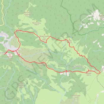
Maljen: od Kraljevog stola do Velikog Maljena i nazad - kruž...
- Distance: 7.9 mi
- Elevation gain: 532 m
- Maximum elevation: 1,075 m
- Elevation loss: 533 m
- Minimum elevation: 775 m
- Moving time: 4 h 18 m
- Moving speed: 1.8 mph
- Maximum speed: 3.0 mph
- Total time: 4 h 45 m
- Global speed: 1.7 mph
Interactive trail map
Trail profile
- Distance: 7.9 mi
- Elevation gain: 532 m
- Maximum elevation: 1,075 m
- Elevation loss: 533 m
- Minimum elevation: 775 m
- Moving time: 4 h 18 m
- Moving speed: 1.8 mph
- Maximum speed: 3.0 mph
- Total time: 4 h 45 m
- Global speed: 1.7 mph
About this trail
Name: Maljen: od Kraljevog stola do Velikog Maljena i nazad - kruž... trail, distance, elevation, map, profile, GPS track
Coordinates: 44.11115 20.01916 44.12933 20.07462
Other hiking, mountain biking, running and outdoor activity trails
Click on a trail to view its statistics, map and profile.
2022_Yu
Slovenia > Ajdovščina > Žapuže
Distance: 1,526.9 mi • Elevation gain: 32,048 m • Maximum elevation: 1,950 m
Divčibare-Rior-Mokra pećina-Ravna planina-Suvobor-Rajac
Serbia > Central Serbia > Kolubara Administrative District > Divcibare
Distance: 16.6 mi • Elevation gain: 826 m • Maximum elevation: 1,020 m