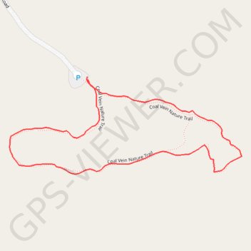
Coal Vein Loop Trail in Theodore Roosevelt National Park
The Coal Vein Trail offers a captivating journey through unique geological formations and remnants of a long-burning coal seam. Hikers pass colorful rock layers, clinker deposits, and exposed clay, with interpretive markers explaining the area’s geological history. The trail is easy to moderate, making it an accessible and enriching way to appreciate the park’s rugged badlands landscape and learn about its fiery past. #Hiking #Loop #Forest #Nature
- Distance: 0.8 mi
- Elevation gain: 13 m
- Maximum elevation: 762 m
- Elevation loss: 13 m
- Minimum elevation: 753 m
- Moving time: 24 m 49 s
- Moving speed: 1.8 mph
- Maximum speed: 3.3 mph
- Total time: 27 m 27 s
- Global speed: 1.7 mph
Interactive trail map
Trail profile
- Distance: 0.8 mi
- Elevation gain: 13 m
- Maximum elevation: 762 m
- Elevation loss: 13 m
- Minimum elevation: 753 m
- Moving time: 24 m 49 s
- Moving speed: 1.8 mph
- Maximum speed: 3.3 mph
- Total time: 27 m 27 s
- Global speed: 1.7 mph
About this trail
Name: Coal Vein Loop Trail in Theodore Roosevelt National Park trail, distance, elevation, map, profile, GPS track
Start: Coal Vein, Coal Vein Road, Billings County, North Dakota, United States (46.92452 -103.40191)
End: Coal Vein, Coal Vein Road, Billings County, North Dakota, United States (46.92457 -103.40193)
Coordinates: 46.92287 -103.40392 46.92457 -103.39798