Make a donation
Gear up for your next adventure:
As an Amazon Associate, this site earns from qualifying purchases at no extra cost to you.
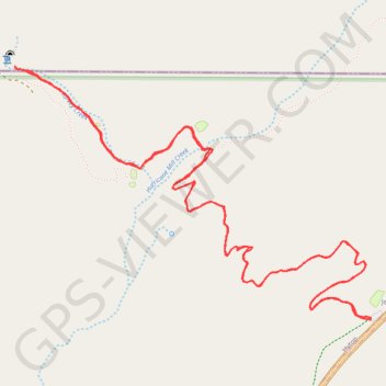
Walls of Jericho Trail in James D. Martin Skyline Wildlife Management Area
The Walls of Jericho Trail offers a striking and immersive hiking experience. Starting from the Alabama trailhead, the hike is characterized by its challenging descent into a gorge framed by towering limestone cliffs. Along the way, hikers traverse various creek crossings, pass through a historic cemetery, and witness the area's unique limestone formations and seasonal waterfalls. The trail culminates at a natural amphitheater where Turkey Creek emerges dramatically from the base of the bluff. #Hiking #Gorge #River #Waterfall #Forest #Nature
- Distance: 6.6 mi
- Elevation gain: 448 m
- Maximum elevation: 542 m
- Elevation loss: 448 m
- Minimum elevation: 220 m
- Moving time: 3 h 46 m
- Moving speed: 1.8 mph
- Maximum speed: 6.7 mph
- Total time: 4 h 11 m
- Global speed: 1.6 mph
Interactive trail map
Make a donation
Gear up for your next adventure:
As an Amazon Associate, this site earns from qualifying purchases at no extra cost to you.
Trail profile
- Distance: 6.6 mi
- Elevation gain: 448 m
- Maximum elevation: 542 m
- Elevation loss: 448 m
- Minimum elevation: 220 m
- Moving time: 3 h 46 m
- Moving speed: 1.8 mph
- Maximum speed: 6.7 mph
- Total time: 4 h 11 m
- Global speed: 1.6 mph
Make a donation
Gear up for your next adventure:
As an Amazon Associate, this site earns from qualifying purchases at no extra cost to you.
About this trail
Name: Walls of Jericho Trail in James D. Martin Skyline Wildlife Management Area trail, distance, elevation, map, profile, GPS track
Coordinates: 34.97659 -86.10376 34.99008 -86.08054
Make a donation
Gear up for your next adventure:
As an Amazon Associate, this site earns from qualifying purchases at no extra cost to you.
Other hiking, mountain biking, running and outdoor activity trails
Click on a trail to view its statistics, map and profile.
Walls of Jericho Hiking Trail
United States > Alabama > Jackson County > Jericho
Distance: 6.7 mi • Elevation gain: 460 m • Maximum elevation: 544 m
Gmaps Pedometer Route
United States > Kentucky > Fulton County > Hickman
Distance: 312.5 mi • Elevation gain: 4,204 m • Maximum elevation: 592 m