Shades of Death Trail in Hickory Run State Park
The Shades of Death Trail is a captivating hike that leads adventurers along the enchanting Sand Spring Run, where cascading waterfalls and lush rhododendron thickets create a picturesque setting. As the trail winds through rocky terrain and offers glimpses of unique rock formations, it delivers a rewarding experience that is both tranquil and invigorating. The remnants of an old logging mill and the rich flora make this trail a remarkable destination for those looking to immerse themselves in nature's beauty. #Hiking #River #Lake #Waterfall #Forest #Nature
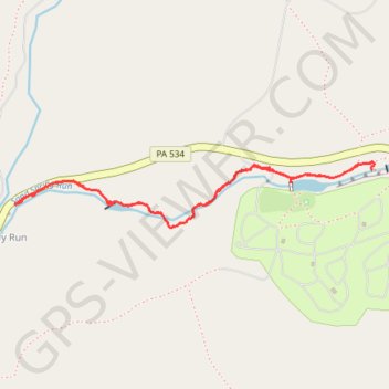
- Distance: 2.3 mi
- Elevation gain: 82 m
- Maximum elevation: 442 m
- Elevation loss: 82 m
- Minimum elevation: 360 m
- Moving time: 1 h 18 m
- Moving speed: 1.7 mph
- Maximum speed: 4.2 mph
- Total time: 1 h 32 m
- Global speed: 1.5 mph
Interactive trail map
Trail profile
- Distance: 2.3 mi
- Elevation gain: 82 m
- Maximum elevation: 442 m
- Elevation loss: 82 m
- Minimum elevation: 360 m
- Moving time: 1 h 18 m
- Moving speed: 1.7 mph
- Maximum speed: 4.2 mph
- Total time: 1 h 32 m
- Global speed: 1.5 mph
About this trail
Name: Shades of Death Trail in Hickory Run State Park trail, distance, elevation, map, profile, GPS track
Coordinates: 41.02377 -75.70973 41.02614 -75.69237