Make a donation
Gear up for your next adventure:
As an Amazon Associate, this site earns from qualifying purchases at no extra cost to you.
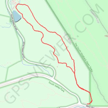
Coyote Song Trail and Swallow Trail Loop in South Valley Park
The Coyote Song and Swallow Trail Loop at South Valley Park offers a peaceful escape through meadows and striking red rock formations, typical of Colorado's Front Range. Hikers will enjoy expansive views of rolling hills and nearby foothills while traversing a mostly level, well-maintained path. It's an easy and scenic hike, making it ideal for families or those looking for a quick outdoor retreat. #Hiking #Loop #Rock #Nature
- Distance: 2.9 mi
- Elevation gain: 105 m
- Maximum elevation: 1,836 m
- Elevation loss: 107 m
- Minimum elevation: 1,754 m
- Moving time: 1 h 4 m
- Moving speed: 2.7 mph
- Maximum speed: 3.7 mph
- Total time: 1 h 4 m
- Global speed: 2.7 mph
Interactive trail map
Make a donation
Gear up for your next adventure:
As an Amazon Associate, this site earns from qualifying purchases at no extra cost to you.
Trail profile
- Distance: 2.9 mi
- Elevation gain: 105 m
- Maximum elevation: 1,836 m
- Elevation loss: 107 m
- Minimum elevation: 1,754 m
- Moving time: 1 h 4 m
- Moving speed: 2.7 mph
- Maximum speed: 3.7 mph
- Total time: 1 h 4 m
- Global speed: 2.7 mph
Make a donation
Gear up for your next adventure:
As an Amazon Associate, this site earns from qualifying purchases at no extra cost to you.
About this trail
Name: Coyote Song Trail and Swallow Trail Loop in South Valley Park trail, distance, elevation, map, profile, GPS track
Start: Coyote Song Trail, Jefferson County, Colorado, 80127, United States (39.55132 -105.13886)
End: Coyote Song Trail, Jefferson County, Colorado, 80127, United States (39.55127 -105.13930)
Coordinates: 39.55127 -105.15279 39.56587 -105.13835
Make a donation
Gear up for your next adventure:
As an Amazon Associate, this site earns from qualifying purchases at no extra cost to you.