Blue Lake Trail in Okanogan-Wenatchee National Forest
The Blue Lake Trail, located in the Okanogan-Wenatchee National Forest, offers a picturesque hike with varied landscapes that appeal to nature lovers. Along the route, you'll traverse through old-growth forests, pass meadows dotted with wildflowers in the summer, and catch glimpses of dramatic granite peaks such as Liberty Bell Mountain and the Early Winter Spires. The trail’s final destination, Blue Lake, is a stunning alpine gem surrounded by larch trees, which turn vibrant golden hues in the fall, providing exceptional views of the cirque and rugged peaks. #Hiking #Mountain #Forest #Nature #Lake
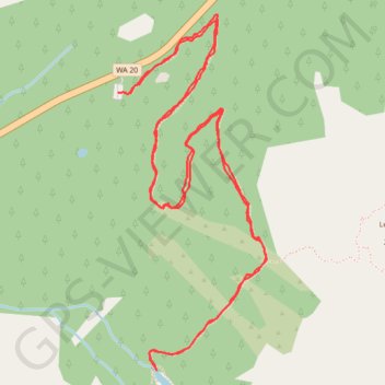
- Distance: 4.6 mi
- Elevation gain: 313 m
- Maximum elevation: 1,907 m
- Elevation loss: 313 m
- Minimum elevation: 1,641 m
- Moving time: 1 h 45 m
- Moving speed: 2.6 mph
- Maximum speed: 6.0 mph
- Total time: 1 h 58 m
- Global speed: 2.3 mph
Interactive trail map
Trail profile
- Distance: 4.6 mi
- Elevation gain: 313 m
- Maximum elevation: 1,907 m
- Elevation loss: 313 m
- Minimum elevation: 1,641 m
- Moving time: 1 h 45 m
- Moving speed: 2.6 mph
- Maximum speed: 6.0 mph
- Total time: 1 h 58 m
- Global speed: 2.3 mph
About this trail
Name: Blue Lake Trail in Okanogan-Wenatchee National Forest trail, distance, elevation, map, profile, GPS track
Coordinates: 48.50836 -120.67429 48.52198 -120.66573
Other hiking, mountain biking, running and outdoor activity trails
Click on a trail to view its statistics, map and profile.
Northern part of the Pacific Crest Trail (PCT)
United States > Oregon > Klamath County
Hike on the Pacific Crest National Scenic Trail from Crater Lake to Canada Border through Oregon and Washington along the Sierra Nevada and Cascade mountain ranges. #Hiking #Mountain #SierraNevada #Cascade #Nature #Forest #Park #PCT
Distance: 744.6 mi • Elevation gain: 44,308 m • Maximum elevation: 2,307 m