Make a donation
Gear up for your next adventure:
As an Amazon Associate, this site earns from qualifying purchases at no extra cost to you.
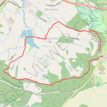
Birdlip Loop via Witcombe Reservoirs
- Distance: 4.9 mi
- Elevation gain: 255 m
- Maximum elevation: 292 m
- Elevation loss: 229 m
- Minimum elevation: 86 m
- Moving time: 2 h 1 m
- Moving speed: 2.4 mph
- Maximum speed: 8.9 mph
- Total time: 2 h 32 m
- Global speed: 1.9 mph
Interactive trail map
Make a donation
Gear up for your next adventure:
As an Amazon Associate, this site earns from qualifying purchases at no extra cost to you.
Trail profile
- Distance: 4.9 mi
- Elevation gain: 255 m
- Maximum elevation: 292 m
- Elevation loss: 229 m
- Minimum elevation: 86 m
- Moving time: 2 h 1 m
- Moving speed: 2.4 mph
- Maximum speed: 8.9 mph
- Total time: 2 h 32 m
- Global speed: 1.9 mph
Make a donation
Gear up for your next adventure:
As an Amazon Associate, this site earns from qualifying purchases at no extra cost to you.
About this trail
Name: Birdlip Loop via Witcombe Reservoirs trail, distance, elevation, map, profile, GPS track
Coordinates: 51.82080 -2.14982 51.83675 -2.10960
Topography: Gloucestershire topographic map, elevation, terrain
Make a donation
Gear up for your next adventure:
As an Amazon Associate, this site earns from qualifying purchases at no extra cost to you.
Other hiking, mountain biking, running and outdoor activity trails
Click on a trail to view its statistics, map and profile.
Painswick Witcombe
United Kingdom > England > Gloucestershire > Painswick > Ham Butts
Distance: 11.6 mi • Elevation gain: 529 m • Maximum elevation: 279 m
Dean2023-311
United Kingdom > England > Oxfordshire > Oxford
Distance: 192.8 mi • Elevation gain: 3,366 m • Maximum elevation: 290 m