Con Smith Park
Morning Run
- Distance: 1.8 mi
- Elevation gain: 12 m
- Maximum elevation: 69 m
- Elevation loss: 11 m
- Minimum elevation: 64 m
- Moving time: 19 m 28 s
- Moving speed: 5.5 mph
- Maximum speed: 8.2 mph
- Total time: 20 m 16 s
- Global speed: 5.2 mph
Interactive trail map
Trail profile
- Distance: 1.8 mi
- Elevation gain: 12 m
- Maximum elevation: 69 m
- Elevation loss: 11 m
- Minimum elevation: 64 m
- Moving time: 19 m 28 s
- Moving speed: 5.5 mph
- Maximum speed: 8.2 mph
- Total time: 20 m 16 s
- Global speed: 5.2 mph
About this trail
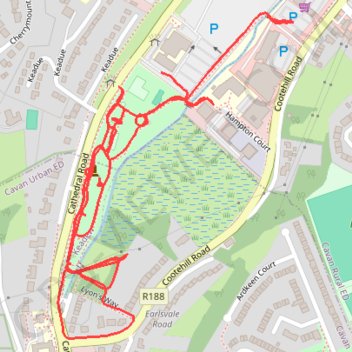
Name: Con Smith Park trail, distance, elevation, map, profile, GPS track
Coordinates: 53.99641 -7.36031 54.00113 -7.35451
Other hiking, mountain biking, running and outdoor activity trails
Click on a trail to view its statistics, map and profile.
Con Smith Park run
Ireland > County Cavan > Cavan
Distance: 3.1 mi • Elevation gain: 39 m • Maximum elevation: 80 m