Lowther hills hillwalk
- Distance: 8.3 mi
- Elevation gain: 594 m
- Maximum elevation: 731 m
- Elevation loss: 594 m
- Minimum elevation: 385 m
- Moving time: 3 h 48 m
- Moving speed: 2.2 mph
- Maximum speed: 6.0 mph
- Total time: 4 h 1 m
- Global speed: 2.1 mph
Interactive trail map
Trail profile
- Distance: 8.3 mi
- Elevation gain: 594 m
- Maximum elevation: 731 m
- Elevation loss: 594 m
- Minimum elevation: 385 m
- Moving time: 3 h 48 m
- Moving speed: 2.2 mph
- Maximum speed: 6.0 mph
- Total time: 4 h 1 m
- Global speed: 2.1 mph
About this trail
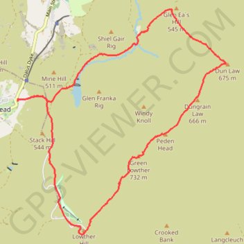
Name: Lowther hills hillwalk trail, distance, elevation, map, profile, GPS track
Start: Dumfries and Galloway, Scotland, ML12 6UP, United Kingdom (55.39874 -3.77175)
End: Dumfries and Galloway, Scotland, ML12 6UP, United Kingdom (55.39873 -3.77170)
Coordinates: 55.37715 -3.77180 55.41357 -3.71255
Topography: Dumfries and Galloway topographic map, elevation, terrain