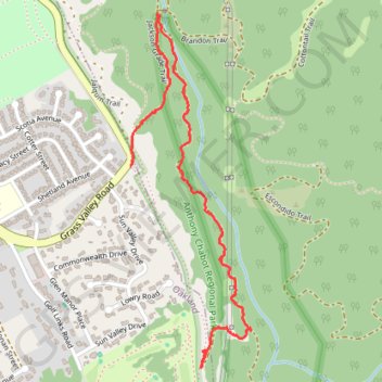
Chabot hike portion
Oakland Walking
- Distance: 1.8 mi
- Elevation gain: 133 m
- Maximum elevation: 193 m
- Elevation loss: 119 m
- Minimum elevation: 122 m
- Moving time: 41 m 57 s
- Moving speed: 2.5 mph
- Maximum speed: 6.6 mph
- Total time: 51 m 37 s
- Global speed: 2.0 mph
Interactive trail map
Trail profile
- Distance: 1.8 mi
- Elevation gain: 133 m
- Maximum elevation: 193 m
- Elevation loss: 119 m
- Minimum elevation: 122 m
- Moving time: 41 m 57 s
- Moving speed: 2.5 mph
- Maximum speed: 6.6 mph
- Total time: 51 m 37 s
- Global speed: 2.0 mph
About this trail
Name: Chabot hike portion trail, distance, elevation, map, profile, GPS track
Start: Goldenrod Trail, Oakland, Alameda County, California, 94577, United States (37.74708 -122.11499)
Coordinates: 37.74644 -122.11848 37.75947 -122.11286