Thank you for supporting this site ❤️
Make a donation
Make a donation
Gear up for your next adventure:
As an Amazon Associate, this site earns from qualifying purchases at no extra cost to you.
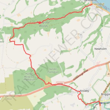
Hike from Sleights to Sandsend via Old Mulgrave Castle
- Distance: 7.1 mi
- Elevation gain: 281 m
- Maximum elevation: 261 m
- Elevation loss: 293 m
- Minimum elevation: 7 m
- Moving time: 2 h 44 m
- Moving speed: 2.6 mph
- Maximum speed: 5.0 mph
- Total time: 3 h 3 m
- Global speed: 2.3 mph
Interactive trail map
Thank you for supporting this site ❤️
Make a donation
Make a donation
Gear up for your next adventure:
As an Amazon Associate, this site earns from qualifying purchases at no extra cost to you.
Trail profile
- Distance: 7.1 mi
- Elevation gain: 281 m
- Maximum elevation: 261 m
- Elevation loss: 293 m
- Minimum elevation: 7 m
- Moving time: 2 h 44 m
- Moving speed: 2.6 mph
- Maximum speed: 5.0 mph
- Total time: 3 h 3 m
- Global speed: 2.3 mph
Thank you for supporting this site ❤️
Make a donation
Make a donation
Gear up for your next adventure:
As an Amazon Associate, this site earns from qualifying purchases at no extra cost to you.
About this trail
Name: Hike from Sleights to Sandsend via Old Mulgrave Castle trail, distance, elevation, map, profile, GPS track
Coordinates: 54.46001 -0.72636 54.50097 -0.66369
Topography: North Yorkshire topographic map, elevation, terrain
Thank you for supporting this site ❤️
Make a donation
Make a donation
Gear up for your next adventure:
As an Amazon Associate, this site earns from qualifying purchases at no extra cost to you.