Thank you for supporting this site ❤️
Make a donation
Make a donation
Gear up for your next adventure:
As an Amazon Associate, this site earns from qualifying purchases at no extra cost to you.
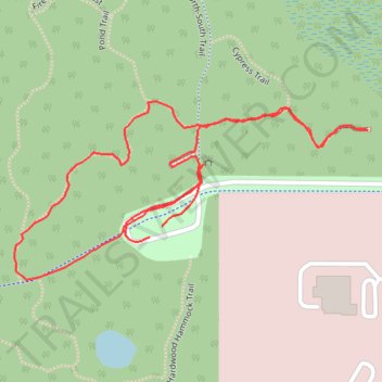
San Felasco Park: Cypress Overlook Trail
- Distance: 1.1 mi
- Elevation gain: 4 m
- Maximum elevation: 59 m
- Elevation loss: 4 m
- Minimum elevation: 55 m
- Moving time: 27 m 4 s
- Moving speed: 2.4 mph
- Maximum speed: 4.3 mph
- Total time: 29 m 8 s
- Global speed: 2.2 mph
Interactive trail map
Thank you for supporting this site ❤️
Make a donation
Make a donation
Gear up for your next adventure:
As an Amazon Associate, this site earns from qualifying purchases at no extra cost to you.
Trail profile
- Distance: 1.1 mi
- Elevation gain: 4 m
- Maximum elevation: 59 m
- Elevation loss: 4 m
- Minimum elevation: 55 m
- Moving time: 27 m 4 s
- Moving speed: 2.4 mph
- Maximum speed: 4.3 mph
- Total time: 29 m 8 s
- Global speed: 2.2 mph
Thank you for supporting this site ❤️
Make a donation
Make a donation
Gear up for your next adventure:
As an Amazon Associate, this site earns from qualifying purchases at no extra cost to you.
About this trail
Name: San Felasco Park: Cypress Overlook Trail trail, distance, elevation, map, profile, GPS track
Coordinates: 29.71199 -82.39433 29.71414 -82.38945
Thank you for supporting this site ❤️
Make a donation
Make a donation
Gear up for your next adventure:
As an Amazon Associate, this site earns from qualifying purchases at no extra cost to you.