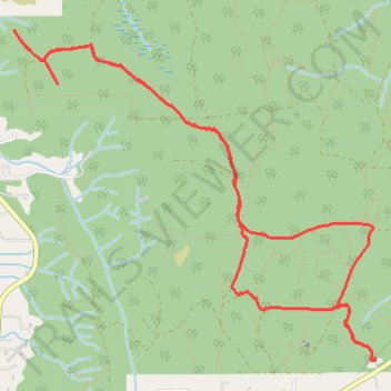
Port Gamble Forest Heritage Park
- Distance: 5.2 mi
- Elevation gain: 131 m
- Maximum elevation: 149 m
- Elevation loss: 130 m
- Minimum elevation: 79 m
- Moving time: 37 m 34 s
- Moving speed: 8.4 mph
- Maximum speed: 17.0 mph
- Total time: 38 m 34 s
- Global speed: 8.1 mph
Interactive trail map
Trail profile
- Distance: 5.2 mi
- Elevation gain: 131 m
- Maximum elevation: 149 m
- Elevation loss: 130 m
- Minimum elevation: 79 m
- Moving time: 37 m 34 s
- Moving speed: 8.4 mph
- Maximum speed: 17.0 mph
- Total time: 38 m 34 s
- Global speed: 8.1 mph
About this trail
Name: Port Gamble Forest Heritage Park trail, distance, elevation, map, profile, GPS track
Start: Stottlemeyer Road Northeast, Kitsap County, Washington, United States (47.78857 -122.59660)
End: Stottlemeyer Road Northeast, Kitsap County, Washington, United States (47.78863 -122.59659)
Coordinates: 47.78857 -122.62653 47.80694 -122.59659