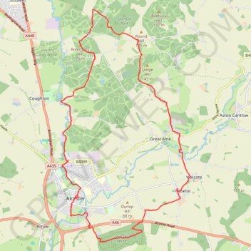
Alcester trail run
Morning Run
- Distance: 13.9 mi
- Elevation gain: 277 m
- Maximum elevation: 124 m
- Elevation loss: 277 m
- Minimum elevation: 37 m
- Moving time: 2 h 12 m
- Moving speed: 6.3 mph
- Maximum speed: 14.0 mph
- Total time: 2 h 12 m
- Global speed: 6.3 mph
Interactive trail map
Trail profile
- Distance: 13.9 mi
- Elevation gain: 277 m
- Maximum elevation: 124 m
- Elevation loss: 277 m
- Minimum elevation: 37 m
- Moving time: 2 h 12 m
- Moving speed: 6.3 mph
- Maximum speed: 14.0 mph
- Total time: 2 h 12 m
- Global speed: 6.3 mph
About this trail
Name: Alcester trail run trail, distance, elevation, map, profile, GPS track
Coordinates: 52.20314 -1.87609 52.26648 -1.81832
Topography: Stratford-on-Avon topographic map, elevation, terrain
Other hiking, mountain biking, running and outdoor activity trails
Click on a trail to view its statistics, map and profile.
Bidford - Oversley Wood trailrun
United Kingdom > England > Warwickshire > Stratford-on-Avon > Bidford on Avon CP
Distance: 12.3 mi • Elevation gain: 238 m • Maximum elevation: 115 m
Henley-in-Arden 🔁 Little Alne
United Kingdom > England > Warwickshire > Stratford-on-Avon > Henley-in-Arden
Distance: 11.4 mi • Elevation gain: 175 m • Maximum elevation: 110 m
Spernall Woods 🔁 Morton Hall
United Kingdom > England > Warwickshire > Stratford-on-Avon
Distance: 11.6 mi • Elevation gain: 221 m • Maximum elevation: 143 m