Thank you for supporting this site ❤️
Make a donation
Make a donation
Gear up for your next adventure:
As an Amazon Associate, this site earns from qualifying purchases at no extra cost to you.
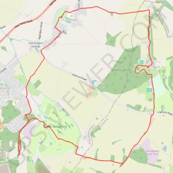
Circular walk through Muxton and Lilleshall
- Distance: 9.3 mi
- Elevation gain: 193 m
- Maximum elevation: 158 m
- Elevation loss: 193 m
- Minimum elevation: 75 m
- Moving time: 3 h 36 m
- Moving speed: 2.6 mph
- Maximum speed: 4.1 mph
- Total time: 4 h 54 m
- Global speed: 1.9 mph
Interactive trail map
Thank you for supporting this site ❤️
Make a donation
Make a donation
Gear up for your next adventure:
As an Amazon Associate, this site earns from qualifying purchases at no extra cost to you.
Trail profile
- Distance: 9.3 mi
- Elevation gain: 193 m
- Maximum elevation: 158 m
- Elevation loss: 193 m
- Minimum elevation: 75 m
- Moving time: 3 h 36 m
- Moving speed: 2.6 mph
- Maximum speed: 4.1 mph
- Total time: 4 h 54 m
- Global speed: 1.9 mph
Thank you for supporting this site ❤️
Make a donation
Make a donation
Gear up for your next adventure:
As an Amazon Associate, this site earns from qualifying purchases at no extra cost to you.
About this trail
Name: Circular walk through Muxton and Lilleshall trail, distance, elevation, map, profile, GPS track
Coordinates: 52.70709 -2.41722 52.73949 -2.37185
Topography: Telford and Wrekin topographic map, elevation, terrain
Thank you for supporting this site ❤️
Make a donation
Make a donation
Gear up for your next adventure:
As an Amazon Associate, this site earns from qualifying purchases at no extra cost to you.