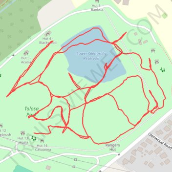
Tolosa Park paths
- Distance: 2.7 mi
- Elevation gain: 45 m
- Maximum elevation: 115 m
- Elevation loss: 47 m
- Minimum elevation: 98 m
- Moving time: 46 m 18 s
- Moving speed: 3.4 mph
- Maximum speed: 5.3 mph
- Total time: 47 m 27 s
- Global speed: 3.4 mph
Interactive trail map
Trail profile
- Distance: 2.7 mi
- Elevation gain: 45 m
- Maximum elevation: 115 m
- Elevation loss: 47 m
- Minimum elevation: 98 m
- Moving time: 46 m 18 s
- Moving speed: 3.4 mph
- Maximum speed: 5.3 mph
- Total time: 47 m 27 s
- Global speed: 3.4 mph
About this trail
Name: Tolosa Park paths trail, distance, elevation, map, profile, GPS track
Coordinates: -42.85198 147.25055 -42.84929 147.25558
Other hiking, mountain biking, running and outdoor activity trails
Click on a trail to view its statistics, map and profile.