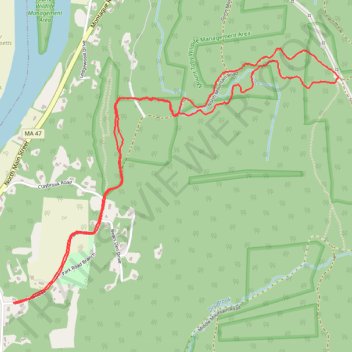
Under Cliffs
- Distance: 4.4 mi
- Elevation gain: 151 m
- Maximum elevation: 179 m
- Elevation loss: 152 m
- Minimum elevation: 57 m
- Moving time: 47 m 37 s
- Moving speed: 5.5 mph
- Maximum speed: 8.4 mph
- Total time: 54 m 58 s
- Global speed: 4.8 mph
Interactive trail map
Trail profile
- Distance: 4.4 mi
- Elevation gain: 151 m
- Maximum elevation: 179 m
- Elevation loss: 152 m
- Minimum elevation: 57 m
- Moving time: 47 m 37 s
- Moving speed: 5.5 mph
- Maximum speed: 8.4 mph
- Total time: 54 m 58 s
- Global speed: 4.8 mph
About this trail
Name: Under Cliffs trail, distance, elevation, map, profile, GPS track
Start: 11, Park Road, Sunderland, Franklin County, Massachusetts, 01375, United States (42.47044 -72.57174)
End: 11, Park Road, Sunderland, Franklin County, Massachusetts, 01375, United States (42.47042 -72.57183)
Coordinates: 42.47037 -72.57183 42.48428 -72.54777
Other hiking, mountain biking, running and outdoor activity trails
Click on a trail to view its statistics, map and profile.
Summit Bypass & Hidden Hill Upper
United States > Massachusetts > Franklin County > Sunderland
Mount Toby State Forest Trail Running
Distance: 9.0 mi • Elevation gain: 377 m • Maximum elevation: 273 m
Summit Alt & Downspout
United States > Massachusetts > Franklin County > Sunderland
Mount Toby State Forest Trail Running
Distance: 6.2 mi • Elevation gain: 247 m • Maximum elevation: 274 m
Mount Toby Loop Trail Run
United States > Massachusetts > Franklin County > Sunderland
Sunderland Trail Running
Distance: 10.6 mi • Elevation gain: 435 m • Maximum elevation: 325 m
Cave Trails
United States > Massachusetts > Franklin County > Sunderland
Distance: 6.2 mi • Elevation gain: 178 m • Maximum elevation: 188 m