Coffee Outside March 2024
- Distance: 19.6 mi
- Elevation gain: 120 m
- Maximum elevation: 47 m
- Elevation loss: 120 m
- Minimum elevation: 21 m
- Moving time: 1 h 48 m
- Moving speed: 10.8 mph
- Maximum speed: 25.7 mph
- Total time: 2 h 50 m
- Global speed: 6.9 mph
Interactive trail map
Trail profile
- Distance: 19.6 mi
- Elevation gain: 120 m
- Maximum elevation: 47 m
- Elevation loss: 120 m
- Minimum elevation: 21 m
- Moving time: 1 h 48 m
- Moving speed: 10.8 mph
- Maximum speed: 25.7 mph
- Total time: 2 h 50 m
- Global speed: 6.9 mph
About this trail
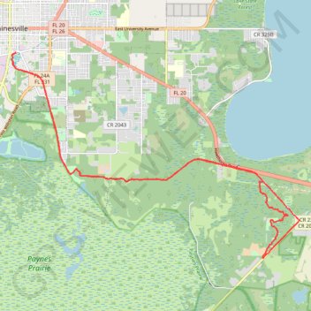
Name: Coffee Outside March 2024 trail, distance, elevation, map, profile, GPS track
Coordinates: 29.58469 -82.32440 29.64479 -82.22782
Other hiking, mountain biking, running and outdoor activity trails
Click on a trail to view its statistics, map and profile.
Hawthorne Trail and Longleaf Flatwoods
United States > Florida > Alachua County > Gainesville
Bike
Distance: 35.1 mi • Elevation gain: 235 m • Maximum elevation: 52 m
Windsor via Hawthorne Road
United States > Florida > Alachua County > Gainesville
Distance: 46.8 mi • Elevation gain: 225 m • Maximum elevation: 61 m
Phifer flatwoods and SRR
United States > Florida > Alachua County > Gainesville
Distance: 67.6 mi • Elevation gain: 419 m • Maximum elevation: 56 m
Newman's lake trails
United States > Florida > Alachua County > Gainesville
Distance: 62.2 mi • Elevation gain: 312 m • Maximum elevation: 59 m
Hawthorne
United States > Florida > Alachua County > Gainesville
Bike
Distance: 54.9 mi • Elevation gain: 429 m • Maximum elevation: 55 m