Thank you for supporting this site ❤️
Make a donation
Make a donation
Gear up for your next adventure:
As an Amazon Associate, this site earns from qualifying purchases at no extra cost to you.
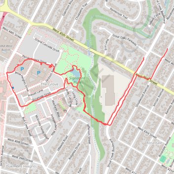
Walk across new suspension bridge to Signature Park across Shoal Creek
- Distance: 2.2 mi
- Elevation gain: 49 m
- Maximum elevation: 206 m
- Elevation loss: 47 m
- Minimum elevation: 177 m
- Moving time: 46 m 10 s
- Moving speed: 2.9 mph
- Maximum speed: 10.2 mph
- Total time: 54 m 33 s
- Global speed: 2.5 mph
Interactive trail map
Thank you for supporting this site ❤️
Make a donation
Make a donation
Gear up for your next adventure:
As an Amazon Associate, this site earns from qualifying purchases at no extra cost to you.
Trail profile
- Distance: 2.2 mi
- Elevation gain: 49 m
- Maximum elevation: 206 m
- Elevation loss: 47 m
- Minimum elevation: 177 m
- Moving time: 46 m 10 s
- Moving speed: 2.9 mph
- Maximum speed: 10.2 mph
- Total time: 54 m 33 s
- Global speed: 2.5 mph
Thank you for supporting this site ❤️
Make a donation
Make a donation
Gear up for your next adventure:
As an Amazon Associate, this site earns from qualifying purchases at no extra cost to you.
About this trail
Name: Walk across new suspension bridge to Signature Park across Shoal Creek trail, distance, elevation, map, profile, GPS track
Coordinates: 30.31441 -97.75507 30.31898 -97.74397
Thank you for supporting this site ❤️
Make a donation
Make a donation
Gear up for your next adventure:
As an Amazon Associate, this site earns from qualifying purchases at no extra cost to you.
Other hiking, mountain biking, running and outdoor activity trails
Click on a trail to view its statistics, map and profile.
Bike ride, fresh trail to Manor
United States > Texas > Travis County > Austin
Crowdstruck
Distance: 37.4 mi • Elevation gain: 396 m • Maximum elevation: 207 m