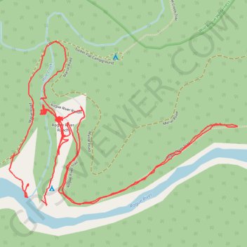
Trails at a spot on the Rogue River
Afternoon Run
- Distance: 3.9 mi
- Elevation gain: 255 m
- Maximum elevation: 166 m
- Elevation loss: 260 m
- Minimum elevation: 105 m
- Moving time: 1 h 34 m
- Moving speed: 2.5 mph
- Maximum speed: 8.0 mph
- Total time: 3 h 1 m
- Global speed: 1.3 mph
Interactive trail map
Trail profile
- Distance: 3.9 mi
- Elevation gain: 255 m
- Maximum elevation: 166 m
- Elevation loss: 260 m
- Minimum elevation: 105 m
- Moving time: 1 h 34 m
- Moving speed: 2.5 mph
- Maximum speed: 8.0 mph
- Total time: 3 h 1 m
- Global speed: 1.3 mph
About this trail
Name: Trails at a spot on the Rogue River trail, distance, elevation, map, profile, GPS track
Start: Rogue River Ranch trail, Curry County, Oregon, United States (42.71568 -123.88291)
End: Rogue River Ranch trail, Curry County, Oregon, United States (42.71618 -123.88374)
Coordinates: 42.71546 -123.88463 42.72191 -123.87240