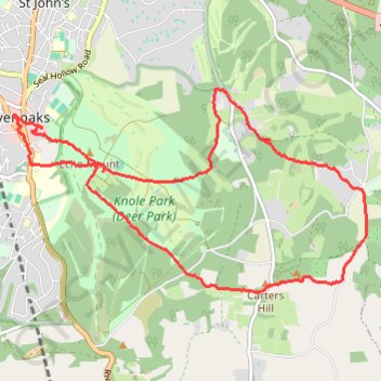
Sevenoaks Knole Park (Deer Park) Loop
- Distance: 8.0 mi
- Elevation gain: 227 m
- Maximum elevation: 205 m
- Elevation loss: 226 m
- Minimum elevation: 127 m
- Moving time: 2 h 41 m
- Moving speed: 3.0 mph
- Maximum speed: 7.0 mph
- Total time: 3 h 37 m
- Global speed: 2.2 mph
Interactive trail map
Trail profile
- Distance: 8.0 mi
- Elevation gain: 227 m
- Maximum elevation: 205 m
- Elevation loss: 226 m
- Minimum elevation: 127 m
- Moving time: 2 h 41 m
- Moving speed: 3.0 mph
- Maximum speed: 7.0 mph
- Total time: 3 h 37 m
- Global speed: 2.2 mph
About this trail
Name: Sevenoaks Knole Park (Deer Park) Loop trail, distance, elevation, map, profile, GPS track
Start: Knole Way, St John's, Sevenoaks, Kent, England, TN13 3RS, United Kingdom (51.27097 0.19569)
Coordinates: 51.25450 0.19138 51.27481 0.24740
Topography: Kent topographic map, elevation, terrain