Massignac Lacs Haute Charente 27 kms
- Distance: 16.8 mi
- Elevation gain: 357 m
- Maximum elevation: 271 m
- Elevation loss: 357 m
- Minimum elevation: 219 m
Interactive trail map
Trail profile
- Distance: 16.8 mi
- Elevation gain: 357 m
- Maximum elevation: 271 m
- Elevation loss: 357 m
- Minimum elevation: 219 m
About this trail
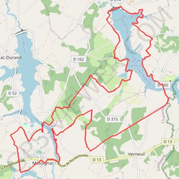
Name: Massignac Lacs Haute Charente 27 kms trail, distance, elevation, map, profile, GPS track
Coordinates: 45.77635 0.64015 45.82673 0.70893
Other hiking, mountain biking, running and outdoor activity trails
Click on a trail to view its statistics, map and profile.
Chemin de Saint-Jacques-de-Compostelle
Switzerland > Geneva > Geneva
Distance: 694.6 mi • Elevation gain: 25,262 m • Maximum elevation: 1,430 m
GR 654 - Le chemin vers Saint-Jacques-de-Compostelle via Vézelay
France > Nouvelle-Aquitaine > Dordogne > Bergerac
Distance: 503.8 mi • Elevation gain: 9,631 m • Maximum elevation: 670 m