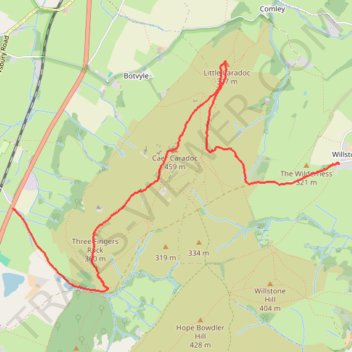
Caer Caradoc walk
- Distance: 3.5 mi
- Elevation gain: 234 m
- Maximum elevation: 453 m
- Elevation loss: 317 m
- Minimum elevation: 183 m
- Moving time: 2 h 30 s
- Moving speed: 1.7 mph
- Maximum speed: 3.3 mph
- Total time: 3 h 30 m
- Global speed: 1.0 mph
Interactive trail map
Trail profile
- Distance: 3.5 mi
- Elevation gain: 234 m
- Maximum elevation: 453 m
- Elevation loss: 317 m
- Minimum elevation: 183 m
- Moving time: 2 h 30 s
- Moving speed: 1.7 mph
- Maximum speed: 3.3 mph
- Total time: 3 h 30 m
- Global speed: 1.0 mph
About this trail
Name: Caer Caradoc walk trail, distance, elevation, map, profile, GPS track
Start: Cwms Road, Willstone, Cardington, Shropshire, England, SY6 7JT, United Kingdom (52.55286 -2.75254)
Coordinates: 52.54372 -2.79107 52.56030 -2.75254
Topography: Shropshire topographic map, elevation, terrain