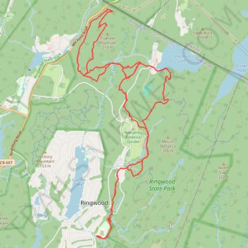
Ringwood
- Distance: 10.8 mi
- Elevation gain: 356 m
- Maximum elevation: 261 m
- Elevation loss: 356 m
- Minimum elevation: 142 m
- Moving time: 1 h 43 m
- Moving speed: 6.3 mph
- Maximum speed: 16.8 mph
- Total time: 1 h 51 m
- Global speed: 5.8 mph
Interactive trail map
Trail profile
- Distance: 10.8 mi
- Elevation gain: 356 m
- Maximum elevation: 261 m
- Elevation loss: 356 m
- Minimum elevation: 142 m
- Moving time: 1 h 43 m
- Moving speed: 6.3 mph
- Maximum speed: 16.8 mph
- Total time: 1 h 51 m
- Global speed: 5.8 mph
About this trail
Name: Ringwood trail, distance, elevation, map, profile, GPS track
Coordinates: 41.10744 -74.24915 41.14552 -74.22859
Other hiking, mountain biking, running and outdoor activity trails
Click on a trail to view its statistics, map and profile.
Northern Ringwood State Park
United States > New Jersey > Passaic County > Ringwood > Erskine Lakes
Distance: 11.3 mi • Elevation gain: 365 m • Maximum elevation: 261 m
Ringwood State Park
United States > New Jersey > Passaic County > Ringwood > Erskine Lakes
Distance: 7.6 mi • Elevation gain: 309 m • Maximum elevation: 327 m