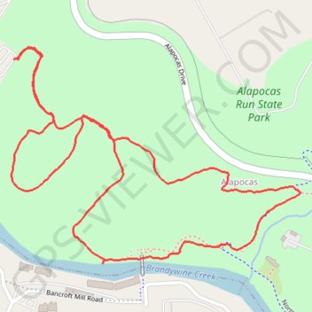
Alapocas Woods Loop Trail in Alapocas Run State Park
The Alapocas Woods Loop Trail offers a serene escape into nature with its lush, wooded surroundings and scenic views of the Brandywine Creek. Hikers can enjoy a well-maintained path lined with diverse tree species and occasional rock formations, which provide an interesting contrast to the greenery. As you navigate the loop, keep an eye out for local wildlife, including birds and small mammals, enhancing the trail's tranquil atmosphere. #Hiking #Loop #Forest #River #Nature
- Distance: 1.8 mi
- Elevation gain: 86 m
- Maximum elevation: 73 m
- Elevation loss: 86 m
- Minimum elevation: 24 m
- Moving time: 45 m 23 s
- Moving speed: 2.4 mph
- Maximum speed: 4.9 mph
- Total time: 49 m 7 s
- Global speed: 2.3 mph
Interactive trail map
Trail profile
- Distance: 1.8 mi
- Elevation gain: 86 m
- Maximum elevation: 73 m
- Elevation loss: 86 m
- Minimum elevation: 24 m
- Moving time: 45 m 23 s
- Moving speed: 2.4 mph
- Maximum speed: 4.9 mph
- Total time: 49 m 7 s
- Global speed: 2.3 mph
About this trail
Name: Alapocas Woods Loop Trail in Alapocas Run State Park trail, distance, elevation, map, profile, GPS track
Start: Old Country Road, Henry Clay, New Castle County, Delaware, 19806, United States (39.77366 -75.56582)
End: Old Country Road, Henry Clay, New Castle County, Delaware, 19806, United States (39.77368 -75.56594)
Coordinates: 39.76909 -75.56600 39.77394 -75.55759