Cross Country Skiing Snowmobile Trail To Bellamy
- Distance: 2.5 mi
- Elevation gain: 33 m
- Maximum elevation: 65 m
- Elevation loss: 9 m
- Minimum elevation: 40 m
- Moving time: 36 m 11 s
- Moving speed: 4.2 mph
- Maximum speed: 14.3 mph
- Total time: 36 m 53 s
- Global speed: 4.1 mph
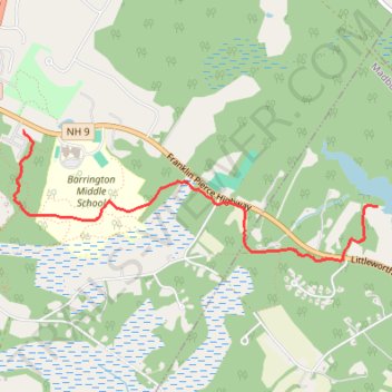
Interactive trail map
Trail profile
- Distance: 2.5 mi
- Elevation gain: 33 m
- Maximum elevation: 65 m
- Elevation loss: 9 m
- Minimum elevation: 40 m
- Moving time: 36 m 11 s
- Moving speed: 4.2 mph
- Maximum speed: 14.3 mph
- Total time: 36 m 53 s
- Global speed: 4.1 mph
About this trail
Name: Cross Country Skiing Snowmobile Trail To Bellamy trail, distance, elevation, map, profile, GPS track
Start: Snowman Trail, Madbury, Strafford County, New Hampshire, 03823, United States (43.20574 -70.96102)
End: The Glen, Barrington, Strafford County, New Hampshire, 30825, United States (43.21052 -70.99172)
Coordinates: 43.20232 -70.99249 43.21052 -70.96102