Twin Rocks Overlook in Piney River Area
- Distance: 2.0 mi
- Elevation gain: 127 m
- Maximum elevation: 370 m
- Elevation loss: 127 m
- Minimum elevation: 270 m
- Moving time: 41 m 10 s
- Moving speed: 2.9 mph
- Maximum speed: 5.1 mph
- Total time: 54 m 8 s
- Global speed: 2.2 mph
Interactive trail map
Trail profile
- Distance: 2.0 mi
- Elevation gain: 127 m
- Maximum elevation: 370 m
- Elevation loss: 127 m
- Minimum elevation: 270 m
- Moving time: 41 m 10 s
- Moving speed: 2.9 mph
- Maximum speed: 5.1 mph
- Total time: 54 m 8 s
- Global speed: 2.2 mph
About this trail
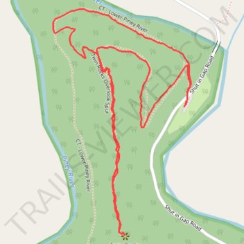
Name: Twin Rocks Overlook in Piney River Area trail, distance, elevation, map, profile, GPS track
Start: Shut in Gap Road, Rhea County, East Tennessee, Tennessee, 37381, United States (35.71327 -84.88084)
End: Shut in Gap Road, Rhea County, East Tennessee, Tennessee, 37381, United States (35.71333 -84.88078)
Coordinates: 35.70947 -84.88564 35.71616 -84.88061
Other hiking, mountain biking, running and outdoor activity trails
Click on a trail to view its statistics, map and profile.
CT - Upper and Lower Piney River
United States > Tennessee > Rhea County
Distance: 12.8 mi • Elevation gain: 505 m • Maximum elevation: 547 m