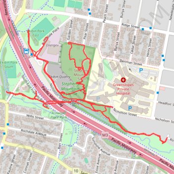
Greenslopes - Stephens Mountain
- Distance: 3.7 mi
- Elevation gain: 95 m
- Maximum elevation: 48 m
- Elevation loss: 95 m
- Minimum elevation: 10 m
- Moving time: 1 h 29 m
- Moving speed: 2.5 mph
- Maximum speed: 4.1 mph
- Total time: 1 h 31 m
- Global speed: 2.4 mph
Interactive trail map
Trail profile
- Distance: 3.7 mi
- Elevation gain: 95 m
- Maximum elevation: 48 m
- Elevation loss: 95 m
- Minimum elevation: 10 m
- Moving time: 1 h 29 m
- Moving speed: 2.5 mph
- Maximum speed: 4.1 mph
- Total time: 1 h 31 m
- Global speed: 2.4 mph
About this trail
Name: Greenslopes - Stephens Mountain trail, distance, elevation, map, profile, GPS track
Coordinates: -27.51590 153.03889 -27.50981 153.04862
Other hiking, mountain biking, running and outdoor activity trails
Click on a trail to view its statistics, map and profile.
2026-07-14_09-46_Tue
Australia > Queensland > Bundaberg
Distance: 253.6 mi • Elevation gain: 3,842 m • Maximum elevation: 173 m
Brisbane - Karawatha
Distance: 13.8 mi • Elevation gain: 239 m • Maximum elevation: 89 m