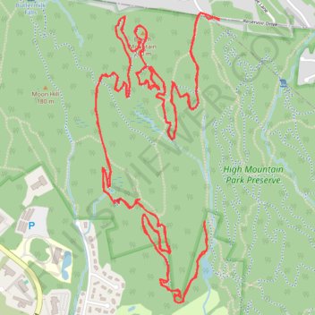
High Mountain Park Preserve - Ancients
- Distance: 10.3 mi
- Elevation gain: 361 m
- Maximum elevation: 256 m
- Elevation loss: 361 m
- Minimum elevation: 143 m
- Moving time: 2 h 28 m
- Moving speed: 4.2 mph
- Maximum speed: 15.2 mph
- Total time: 2 h 42 m
- Global speed: 3.8 mph
Interactive trail map
Trail profile
- Distance: 10.3 mi
- Elevation gain: 361 m
- Maximum elevation: 256 m
- Elevation loss: 361 m
- Minimum elevation: 143 m
- Moving time: 2 h 28 m
- Moving speed: 4.2 mph
- Maximum speed: 15.2 mph
- Total time: 2 h 42 m
- Global speed: 3.8 mph
About this trail
Name: High Mountain Park Preserve - Ancients trail, distance, elevation, map, profile, GPS track
Coordinates: 40.96484 -74.21988 40.98045 -74.21107
Other hiking, mountain biking, running and outdoor activity trails
Click on a trail to view its statistics, map and profile.
High Mountain Hardtail
United States > New Jersey > Bergen County > Franklin Lakes
Distance: 9.2 mi • Elevation gain: 329 m • Maximum elevation: 261 m