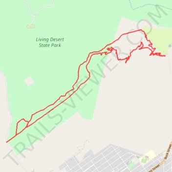
Broken Hill MTB Nine Mile Extension
- Distance: 9.1 mi
- Elevation gain: 159 m
- Maximum elevation: 352 m
- Elevation loss: 159 m
- Minimum elevation: 290 m
- Moving time: 1 h 14 m
- Moving speed: 7.4 mph
- Maximum speed: 18.8 mph
- Total time: 1 h 34 m
- Global speed: 5.8 mph
Interactive trail map
Trail profile
- Distance: 9.1 mi
- Elevation gain: 159 m
- Maximum elevation: 352 m
- Elevation loss: 159 m
- Minimum elevation: 290 m
- Moving time: 1 h 14 m
- Moving speed: 7.4 mph
- Maximum speed: 18.8 mph
- Total time: 1 h 34 m
- Global speed: 5.8 mph
About this trail
Name: Broken Hill MTB Nine Mile Extension trail, distance, elevation, map, profile, GPS track
Coordinates: -31.93322 141.43611 -31.90812 141.47786
Other hiking, mountain biking, running and outdoor activity trails
Click on a trail to view its statistics, map and profile.
Broken Hill MTB Loop
Australia > New South Wales > Broken Hill City Council > Broken Hill
Distance: 5.4 mi • Elevation gain: 143 m • Maximum elevation: 351 m