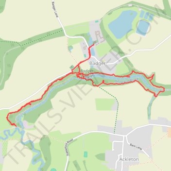
Walk around Badger Dingle
- Distance: 2.9 mi
- Elevation gain: 47 m
- Maximum elevation: 76 m
- Elevation loss: 47 m
- Minimum elevation: 50 m
- Moving time: 1 h 15 m
- Moving speed: 2.3 mph
- Maximum speed: 4.6 mph
- Total time: 1 h 27 m
- Global speed: 2.0 mph
Interactive trail map
Trail profile
- Distance: 2.9 mi
- Elevation gain: 47 m
- Maximum elevation: 76 m
- Elevation loss: 47 m
- Minimum elevation: 50 m
- Moving time: 1 h 15 m
- Moving speed: 2.3 mph
- Maximum speed: 4.6 mph
- Total time: 1 h 27 m
- Global speed: 2.0 mph
About this trail
Name: Walk around Badger Dingle trail, distance, elevation, map, profile, GPS track
Start: Badger Lane, Badger, Shropshire, England, WV6 7JS, United Kingdom (52.59364 -2.34387)
End: Badger Lane, Badger, Shropshire, England, WV6 7JS, United Kingdom (52.59366 -2.34380)
Coordinates: 52.58747 -2.35474 52.59366 -2.33498
Topography: Shropshire topographic map, elevation, terrain
Other hiking, mountain biking, running and outdoor activity trails
Click on a trail to view its statistics, map and profile.
Beckbury Badger Cicular walk
United Kingdom > England > Shropshire > Beckbury
Distance: 6.2 mi • Elevation gain: 107 m • Maximum elevation: 99 m