Thank you for supporting this site ❤️
Make a donation
Make a donation
Gear up for your next adventure:
As an Amazon Associate, this site earns from qualifying purchases at no extra cost to you.
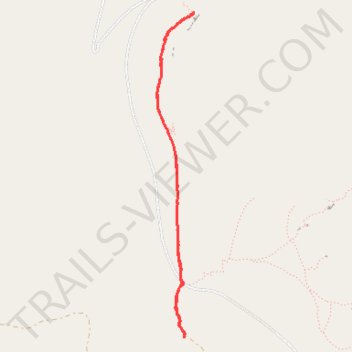
Trailhead Wall via North Country South Trail
- Distance: 3.5 mi
- Elevation gain: 98 m
- Maximum elevation: 2,685 m
- Elevation loss: 98 m
- Minimum elevation: 2,613 m
- Moving time: 42 m 33 s
- Moving speed: 4.9 mph
- Maximum speed: 7.9 mph
- Total time: 42 m 33 s
- Global speed: 4.9 mph
Interactive trail map
Thank you for supporting this site ❤️
Make a donation
Make a donation
Gear up for your next adventure:
As an Amazon Associate, this site earns from qualifying purchases at no extra cost to you.
Trail profile
- Distance: 3.5 mi
- Elevation gain: 98 m
- Maximum elevation: 2,685 m
- Elevation loss: 98 m
- Minimum elevation: 2,613 m
- Moving time: 42 m 33 s
- Moving speed: 4.9 mph
- Maximum speed: 7.9 mph
- Total time: 42 m 33 s
- Global speed: 4.9 mph
Thank you for supporting this site ❤️
Make a donation
Make a donation
Gear up for your next adventure:
As an Amazon Associate, this site earns from qualifying purchases at no extra cost to you.
About this trail
Name: Trailhead Wall via North Country South Trail trail, distance, elevation, map, profile, GPS track
Start: Limestone Mountain Road, Fremont County, Wyoming, United States (42.58255 -108.75122)
End: Limestone Mountain Road, Fremont County, Wyoming, United States (42.58281 -108.75119)
Coordinates: 42.58255 -108.75380 42.60502 -108.75032
Thank you for supporting this site ❤️
Make a donation
Make a donation
Gear up for your next adventure:
As an Amazon Associate, this site earns from qualifying purchases at no extra cost to you.