Thank you for supporting this site ❤️
Make a donation
Make a donation
Gear up for your next adventure:
As an Amazon Associate, this site earns from qualifying purchases at no extra cost to you.
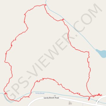
Hiking Trail in Colebrook, CT
Afternoon hike
- Distance: 1.5 mi
- Elevation gain: 55 m
- Maximum elevation: 359 m
- Elevation loss: 55 m
- Minimum elevation: 314 m
- Moving time: 48 m 16 s
- Moving speed: 1.9 mph
- Maximum speed: 6.2 mph
- Total time: 51 m 38 s
- Global speed: 1.8 mph
Interactive trail map
Thank you for supporting this site ❤️
Make a donation
Make a donation
Gear up for your next adventure:
As an Amazon Associate, this site earns from qualifying purchases at no extra cost to you.
Trail profile
- Distance: 1.5 mi
- Elevation gain: 55 m
- Maximum elevation: 359 m
- Elevation loss: 55 m
- Minimum elevation: 314 m
- Moving time: 48 m 16 s
- Moving speed: 1.9 mph
- Maximum speed: 6.2 mph
- Total time: 51 m 38 s
- Global speed: 1.8 mph
Thank you for supporting this site ❤️
Make a donation
Make a donation
Gear up for your next adventure:
As an Amazon Associate, this site earns from qualifying purchases at no extra cost to you.
About this trail
Name: Hiking Trail in Colebrook, CT trail, distance, elevation, map, profile, GPS track
Coordinates: 42.01408 -73.10245 42.01887 -73.09593
Thank you for supporting this site ❤️
Make a donation
Make a donation
Gear up for your next adventure:
As an Amazon Associate, this site earns from qualifying purchases at no extra cost to you.