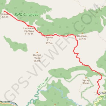
Planinarski dom Brezna - vrh Kamarišta (Usovica) 1375 mnv
- Distance: 13.6 mi
- Elevation gain: 989 m
- Maximum elevation: 1,371 m
- Elevation loss: 989 m
- Minimum elevation: 629 m
- Moving time: 5 h 10 m
- Moving speed: 2.6 mph
- Maximum speed: 10.6 mph
- Total time: 6 h 32 m
- Global speed: 2.1 mph
Interactive trail map
Trail profile
- Distance: 13.6 mi
- Elevation gain: 989 m
- Maximum elevation: 1,371 m
- Elevation loss: 989 m
- Minimum elevation: 629 m
- Moving time: 5 h 10 m
- Moving speed: 2.6 mph
- Maximum speed: 10.6 mph
- Total time: 6 h 32 m
- Global speed: 2.1 mph
About this trail
Name: Planinarski dom Brezna - vrh Kamarišta (Usovica) 1375 mnv trail, distance, elevation, map, profile, GPS track
Coordinates: 43.56561 20.61119 43.60918 20.68179
Other hiking, mountain biking, running and outdoor activity trails
Click on a trail to view its statistics, map and profile.
2022_Yu
Slovenia > Ajdovščina > Žapuže
Distance: 1,526.9 mi • Elevation gain: 32,048 m • Maximum elevation: 1,950 m
Stolovi: od Magliča grebenom Lipar, vrh Usovica, povratak gr...
Serbia > Central Serbia > Raska Administrative District > Maglic
Distance: 10.1 mi • Elevation gain: 1,362 m • Maximum elevation: 1,372 m