Import a GPX file

Cross Plains State Park loop hike

  • Distance: 1.9 mi
  • Elevation gain: 70 m
  • Maximum elevation: 339 m
  • Elevation loss: 70 m
  • Minimum elevation: 297 m
  • Moving time: 47 m 1 s
  • Moving speed: 2.4 mph
  • Maximum speed: 5.0 mph
  • Total time: 50 m 58 s
  • Global speed: 2.2 mph

Interactive trail map

Trail profile

  • Distance: 1.9 mi
  • Elevation gain: 70 m
  • Maximum elevation: 339 m
  • Elevation loss: 70 m
  • Minimum elevation: 297 m
  • Moving time: 47 m 1 s
  • Moving speed: 2.4 mph
  • Maximum speed: 5.0 mph
  • Total time: 50 m 58 s
  • Global speed: 2.2 mph

About this trail
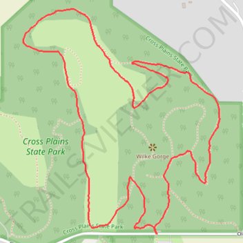
Name: Cross Plains State Park loop hike trail, distance, elevation, map, profile, GPS track

Start: 8034, Old Sauk Pass Road, Town of Cross Plains, Dane County, Wisconsin, 53528, United States (43.08217 -89.60916)

End: 8034, Old Sauk Pass Road, Town of Cross Plains, Dane County, Wisconsin, 53528, United States (43.08217 -89.60914)

Coordinates: 43.08217 -89.61412 43.08829 -89.60680

Gear up for your next adventure:

🔥Emergency Fire Starters - Reliable ignition tools for survival situations in damp conditions
🗺️Ordnance Survey Maps - Essential paper maps for hiking across the UK national parks
🧤Thermal Touchscreen Gloves - Stay warm while operating your GPS or smartphone camera
🧰Survival Kits - Emergency tools for remote environments
⛺Lightweight Solo Tents - Backpacking tents designed for wild camping in the UK highlands

As an Amazon Associate, this site earns from qualifying purchases at no extra cost to you.