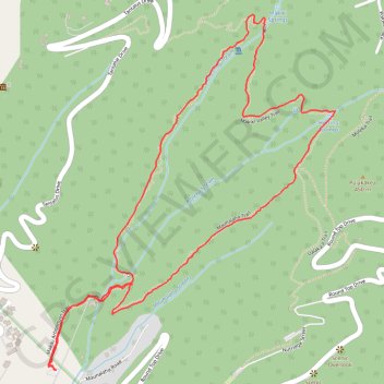
Honolulu Hawaii, Makiki Valley Trail Loop
Round Top Forest Reserve
- Distance: 3.1 mi
- Elevation gain: 311 m
- Maximum elevation: 335 m
- Elevation loss: 310 m
- Minimum elevation: 82 m
- Moving time: 1 h 40 m
- Moving speed: 1.9 mph
- Maximum speed: 3.2 mph
- Total time: 1 h 57 m
- Global speed: 1.6 mph
Interactive trail map
Trail profile
- Distance: 3.1 mi
- Elevation gain: 311 m
- Maximum elevation: 335 m
- Elevation loss: 310 m
- Minimum elevation: 82 m
- Moving time: 1 h 40 m
- Moving speed: 1.9 mph
- Maximum speed: 3.2 mph
- Total time: 1 h 57 m
- Global speed: 1.6 mph
About this trail
Name: Honolulu Hawaii, Makiki Valley Trail Loop trail, distance, elevation, map, profile, GPS track
Coordinates: 21.31405 -157.82952 21.32674 -157.81852
Other hiking, mountain biking, running and outdoor activity trails
Click on a trail to view its statistics, map and profile.
Trail Router route
United States > Hawaii > Honolulu County > Honolulu
Distance: 13.7 mi • Elevation gain: 1,288 m • Maximum elevation: 573 m