Thank you for supporting this site ❤️
Make a donation
Make a donation
Gear up for your next adventure:
As an Amazon Associate, this site earns from qualifying purchases at no extra cost to you.
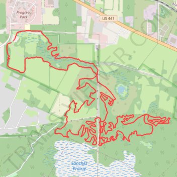
Some of the bike trails at San Felasco Preserve State Park
- Distance: 19.4 mi
- Elevation gain: 266 m
- Maximum elevation: 57 m
- Elevation loss: 268 m
- Minimum elevation: 21 m
- Moving time: 1 h 55 m
- Moving speed: 10.0 mph
- Maximum speed: 19.3 mph
- Total time: 2 h 45 m
- Global speed: 7.0 mph
Interactive trail map
Thank you for supporting this site ❤️
Make a donation
Make a donation
Gear up for your next adventure:
As an Amazon Associate, this site earns from qualifying purchases at no extra cost to you.
Trail profile
- Distance: 19.4 mi
- Elevation gain: 266 m
- Maximum elevation: 57 m
- Elevation loss: 268 m
- Minimum elevation: 21 m
- Moving time: 1 h 55 m
- Moving speed: 10.0 mph
- Maximum speed: 19.3 mph
- Total time: 2 h 45 m
- Global speed: 7.0 mph
Thank you for supporting this site ❤️
Make a donation
Make a donation
Gear up for your next adventure:
As an Amazon Associate, this site earns from qualifying purchases at no extra cost to you.
About this trail
Name: Some of the bike trails at San Felasco Preserve State Park trail, distance, elevation, map, profile, GPS track
Start: Cellon Creek Loop, Alachua, Alachua County, Florida, 32615, United States (29.77495 -82.47432)
End: Cellon Creek Loop, Alachua, Alachua County, Florida, 32615, United States (29.77459 -82.47485)
Coordinates: 29.75412 -82.47586 29.77697 -82.43848
Thank you for supporting this site ❤️
Make a donation
Make a donation
Gear up for your next adventure:
As an Amazon Associate, this site earns from qualifying purchases at no extra cost to you.