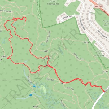
Loop hike in Harold Parker State Forest
- Distance: 2.4 mi
- Elevation gain: 22 m
- Maximum elevation: 56 m
- Elevation loss: 22 m
- Minimum elevation: 39 m
- Moving time: 1 h 7 m
- Moving speed: 2.1 mph
- Maximum speed: 12.7 mph
- Total time: 1 h 31 m
- Global speed: 1.6 mph
Interactive trail map
Trail profile
- Distance: 2.4 mi
- Elevation gain: 22 m
- Maximum elevation: 56 m
- Elevation loss: 22 m
- Minimum elevation: 39 m
- Moving time: 1 h 7 m
- Moving speed: 2.1 mph
- Maximum speed: 12.7 mph
- Total time: 1 h 31 m
- Global speed: 1.6 mph
About this trail
Name: Loop hike in Harold Parker State Forest trail, distance, elevation, map, profile, GPS track
Start: Stearns Pond Road, North Andover, Essex County, Massachusetts, United States (42.62550 -71.06963)
End: Harold Parker Road, North Andover, Essex County, Massachusetts, United States (42.62549 -71.06982)
Coordinates: 42.62549 -71.08121 42.63182 -71.06963