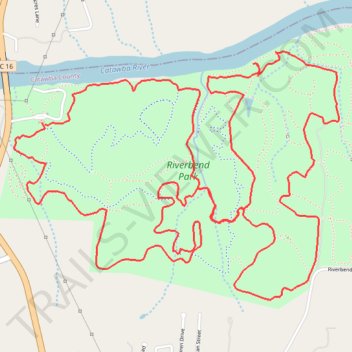
Riverbend Park Trails
- Distance: 7.9 mi
- Elevation gain: 188 m
- Maximum elevation: 315 m
- Elevation loss: 187 m
- Minimum elevation: 259 m
- Moving time: 1 h 32 m
- Moving speed: 5.1 mph
- Maximum speed: 8.0 mph
- Total time: 1 h 33 m
- Global speed: 5.0 mph
Interactive trail map
Trail profile
- Distance: 7.9 mi
- Elevation gain: 188 m
- Maximum elevation: 315 m
- Elevation loss: 187 m
- Minimum elevation: 259 m
- Moving time: 1 h 32 m
- Moving speed: 5.1 mph
- Maximum speed: 8.0 mph
- Total time: 1 h 33 m
- Global speed: 5.0 mph
About this trail
Name: Riverbend Park Trails trail, distance, elevation, map, profile, GPS track
Start: Blue Trail, Catawba County, North Carolina, United States (35.81980 -81.18794)
End: Blue Trail, Catawba County, North Carolina, United States (35.81968 -81.18773)
Coordinates: 35.81023 -81.18984 35.82362 -81.16824
Other hiking, mountain biking, running and outdoor activity trails
Click on a trail to view its statistics, map and profile.
Riverbend Park Blue Trail
United States > North Carolina > Catawba County
Distance: 4.4 mi • Elevation gain: 116 m • Maximum elevation: 310 m