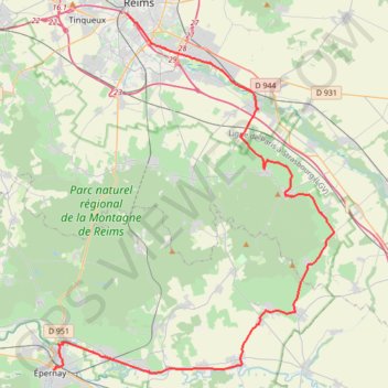
Reims - Epernay
- Distance: 32.5 mi
- Elevation gain: 419 m
- Maximum elevation: 188 m
- Elevation loss: 420 m
- Minimum elevation: 68 m
- Moving time: 1 d 8 h
- Moving speed: 1.0 mph
- Maximum speed: 3.4 mph
- Total time: 2 d 8 h
- Global speed: 0.6 mph
Interactive trail map
Trail profile
- Distance: 32.5 mi
- Elevation gain: 419 m
- Maximum elevation: 188 m
- Elevation loss: 420 m
- Minimum elevation: 68 m
- Moving time: 1 d 8 h
- Moving speed: 1.0 mph
- Maximum speed: 3.4 mph
- Total time: 2 d 8 h
- Global speed: 0.6 mph
About this trail
Name: Reims - Epernay trail, distance, elevation, map, profile, GPS track
Start: Voie Jean Taittinger, Reims, Marne, Grand Est, Metropolitan France, 51100, France (49.25093 4.02223)
Coordinates: 49.04208 3.95687 49.25093 4.20583
Other hiking, mountain biking, running and outdoor activity trails
Click on a trail to view its statistics, map and profile.
Route Touristique du Champagne : Montagne de Reims
France > Grand Est > Marne > Reims
Ses versants harmonieux constituent l'une des plus belles richesses viticoles françaises. Au départ de Reims ou d'Épernay (l'itinéraire est fléché dans les deux sens), 70 kilomètres à parcourir au coeur d'un Parc Naturel Régional. Un plongeon dans l'histoire de Reims, où les pieds de vigne…
Distance: 69.1 mi • Elevation gain: 1,435 m • Maximum elevation: 283 m
Exc. Reims - Massif St Thierry - Reims
France > Grand Est > Marne > Reims
Distance: 27.0 mi • Elevation gain: 505 m • Maximum elevation: 216 m
Eurovelo 15 - Strasbourg Rotterdam
France > Grand Est > Bas-Rhin > Strasbourg
Distance: 554.1 mi • Elevation gain: 2,104 m • Maximum elevation: 146 m