Thank you for supporting this site ❤️
Make a donation
Make a donation
Gear up for your next adventure:
As an Amazon Associate, this site earns from qualifying purchases at no extra cost to you.
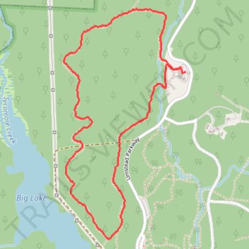
Sal's Branch Loop Trail in William B. Umstead State Park
- Distance: 2.4 mi
- Elevation gain: 43 m
- Maximum elevation: 141 m
- Elevation loss: 43 m
- Minimum elevation: 114 m
- Moving time: 1 h 7 m
- Moving speed: 2.1 mph
- Maximum speed: 3.4 mph
- Total time: 1 h 8 m
- Global speed: 2.1 mph
Interactive trail map
Thank you for supporting this site ❤️
Make a donation
Make a donation
Gear up for your next adventure:
As an Amazon Associate, this site earns from qualifying purchases at no extra cost to you.
Trail profile
- Distance: 2.4 mi
- Elevation gain: 43 m
- Maximum elevation: 141 m
- Elevation loss: 43 m
- Minimum elevation: 114 m
- Moving time: 1 h 7 m
- Moving speed: 2.1 mph
- Maximum speed: 3.4 mph
- Total time: 1 h 8 m
- Global speed: 2.1 mph
Thank you for supporting this site ❤️
Make a donation
Make a donation
Gear up for your next adventure:
As an Amazon Associate, this site earns from qualifying purchases at no extra cost to you.
About this trail
Name: Sal's Branch Loop Trail in William B. Umstead State Park trail, distance, elevation, map, profile, GPS track
Start: Sal's Branch Trail, Raleigh, Wake County, North Carolina, 27617, United States (35.88070 -78.75823)
End: Sal's Branch Trail, Raleigh, Wake County, North Carolina, 27617, United States (35.88092 -78.75848)
Coordinates: 35.87218 -78.76582 35.88388 -78.75823
Thank you for supporting this site ❤️
Make a donation
Make a donation
Gear up for your next adventure:
As an Amazon Associate, this site earns from qualifying purchases at no extra cost to you.