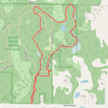
Dauner Martin Nature Sanctuary Blue and Green Trails Loop
- Distance: 1.6 mi
- Elevation gain: 11 m
- Maximum elevation: 277 m
- Elevation loss: 10 m
- Minimum elevation: 268 m
- Moving time: 29 m 15 s
- Moving speed: 3.3 mph
- Maximum speed: 7.7 mph
- Total time: 29 m 15 s
- Global speed: 3.3 mph
Interactive trail map
Trail profile
- Distance: 1.6 mi
- Elevation gain: 11 m
- Maximum elevation: 277 m
- Elevation loss: 10 m
- Minimum elevation: 268 m
- Moving time: 29 m 15 s
- Moving speed: 3.3 mph
- Maximum speed: 7.7 mph
- Total time: 29 m 15 s
- Global speed: 3.3 mph
About this trail
Name: Dauner Martin Nature Sanctuary Blue and Green Trails Loop trail, distance, elevation, map, profile, GPS track
Start: Blue Trail, Fenton, Genesee County, Michigan, 48430, United States (42.81260 -83.69827)
End: Blue Trail, Fenton, Genesee County, Michigan, 48430, United States (42.81268 -83.69817)
Coordinates: 42.81260 -83.69831 42.81977 -83.69381