Make a donation
Gear up for your next adventure:
As an Amazon Associate, this site earns from qualifying purchases at no extra cost to you.
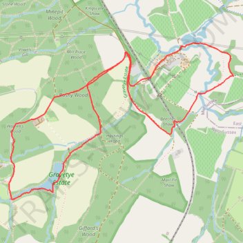
Gravetye Estate Loop
- Distance: 3.5 mi
- Elevation gain: 113 m
- Maximum elevation: 136 m
- Elevation loss: 113 m
- Minimum elevation: 77 m
- Moving time: 1 h 7 m
- Moving speed: 3.1 mph
- Maximum speed: 14.2 mph
- Total time: 1 h 25 m
- Global speed: 2.5 mph
Interactive trail map
Make a donation
Gear up for your next adventure:
As an Amazon Associate, this site earns from qualifying purchases at no extra cost to you.
Trail profile
- Distance: 3.5 mi
- Elevation gain: 113 m
- Maximum elevation: 136 m
- Elevation loss: 113 m
- Minimum elevation: 77 m
- Moving time: 1 h 7 m
- Moving speed: 3.1 mph
- Maximum speed: 14.2 mph
- Total time: 1 h 25 m
- Global speed: 2.5 mph
Make a donation
Gear up for your next adventure:
As an Amazon Associate, this site earns from qualifying purchases at no extra cost to you.
About this trail
Name: Gravetye Estate Loop trail, distance, elevation, map, profile, GPS track
Coordinates: 51.08801 -0.05548 51.09756 -0.03362
Topography: Mid Sussex topographic map, elevation, terrain
Make a donation
Gear up for your next adventure:
As an Amazon Associate, this site earns from qualifying purchases at no extra cost to you.
Other hiking, mountain biking, running and outdoor activity trails
Click on a trail to view its statistics, map and profile.
Gravetye Estate Loop
United Kingdom > England > West Sussex > Mid Sussex > West Hoathly > Selsfield Common
Loop hike from Vowels Lane via Warren's Wood, Lower Lake, Hastings Wood, Beeches Shaw, River Medway, Weir Wood Reservoir, Mill Place Farm, Kingscote Shaw, Kingscote Railway Station, Minepit Wood, Mill Place Wood, Bushy Wood and Vowels Gill in the Gravetye Estate and the High Weald National Landscape. #Hiking…
Distance: 7.9 mi • Elevation gain: 254 m • Maximum elevation: 149 m
Gravetye Estate Loop
United Kingdom > England > West Sussex > Mid Sussex > West Hoathly > Selsfield Common
Distance: 3.6 mi • Elevation gain: 117 m • Maximum elevation: 175 m