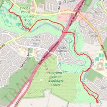
South Austin Single Track
- Distance: 4.6 mi
- Elevation gain: 16 m
- Maximum elevation: 271 m
- Elevation loss: 48 m
- Minimum elevation: 231 m
- Moving time: 35 m 58 s
- Moving speed: 7.6 mph
- Maximum speed: 23.0 mph
- Total time: 42 m 23 s
- Global speed: 6.5 mph
Interactive trail map
Trail profile
- Distance: 4.6 mi
- Elevation gain: 16 m
- Maximum elevation: 271 m
- Elevation loss: 48 m
- Minimum elevation: 231 m
- Moving time: 35 m 58 s
- Moving speed: 7.6 mph
- Maximum speed: 23.0 mph
- Total time: 42 m 23 s
- Global speed: 6.5 mph
About this trail
Name: South Austin Single Track trail, distance, elevation, map, profile, GPS track
Start: Burner, Austin, Travis County, Texas, 78739, United States (30.20313 -97.88499)
End: Violet Crown Trail, Austin, Travis County, Texas, 78739, United States (30.18659 -97.86191)
Coordinates: 30.17741 -97.88634 30.20321 -97.85927
Other hiking, mountain biking, running and outdoor activity trails
Click on a trail to view its statistics, map and profile.
Violet Crown Trail from Slaughter Creek to Wildflower Center
United States > Texas > Travis County > Austin
Distance: 4.7 mi • Elevation gain: 39 m • Maximum elevation: 257 m