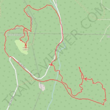
Forestry Lookout and 3 Sisters Loop
- Distance: 3.3 mi
- Elevation gain: 226 m
- Maximum elevation: 426 m
- Elevation loss: 225 m
- Minimum elevation: 309 m
- Moving time: 1 h 33 m
- Moving speed: 2.1 mph
- Maximum speed: 10.3 mph
- Total time: 1 h 48 m
- Global speed: 1.8 mph
Interactive trail map
Trail profile
- Distance: 3.3 mi
- Elevation gain: 226 m
- Maximum elevation: 426 m
- Elevation loss: 225 m
- Minimum elevation: 309 m
- Moving time: 1 h 33 m
- Moving speed: 2.1 mph
- Maximum speed: 10.3 mph
- Total time: 1 h 48 m
- Global speed: 1.8 mph
About this trail
Name: Forestry Lookout and 3 Sisters Loop trail, distance, elevation, map, profile, GPS track
Coordinates: 49.26934 -124.74113 49.27811 -124.72745
Other hiking, mountain biking, running and outdoor activity trails
Click on a trail to view its statistics, map and profile.
Sproat Lake - Nanaimo
Canada > British Columbia > Alberni-Clayoquot Regional District > Area D (Sproat Lake)
Distance: 54.0 mi • Elevation gain: 1,273 m • Maximum elevation: 422 m
Parks paths
Canada > British Columbia > Regional District of Nanaimo > Parksville
Distance: 30.3 mi • Elevation gain: 918 m • Maximum elevation: 424 m