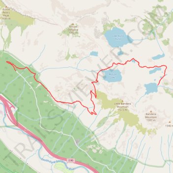
Island Lake via Ira Spring Trail, Mason Lake and Mount Defiance Trail in Alpine Lakes Wilderness
- Distance: 5.2 mi
- Elevation gain: 819 m
- Maximum elevation: 1,363 m
- Elevation loss: 168 m
- Minimum elevation: 652 m
- Moving time: 2 h 20 m
- Moving speed: 2.2 mph
- Maximum speed: 10.8 mph
- Total time: 3 h 55 m
- Global speed: 1.3 mph
Interactive trail map
Trail profile
- Distance: 5.2 mi
- Elevation gain: 819 m
- Maximum elevation: 1,363 m
- Elevation loss: 168 m
- Minimum elevation: 652 m
- Moving time: 2 h 20 m
- Moving speed: 2.2 mph
- Maximum speed: 10.8 mph
- Total time: 3 h 55 m
- Global speed: 1.3 mph
About this trail
Name: Island Lake via Ira Spring Trail, Mason Lake and Mount Defiance Trail in Alpine Lakes Wilderness trail, distance, elevation, map, profile, GPS track
Start: Ira Spring Trailhead, Mason Lake Road, King County, Washington, United States (47.42473 -121.58350)
End: Island Lake Trail, King County, Washington, United States (47.42156 -121.53613)
Coordinates: 47.41486 -121.58661 47.42758 -121.53306
Other hiking, mountain biking, running and outdoor activity trails
Click on a trail to view its statistics, map and profile.
Mount Defiance Trail via Ira Spring Trail and Mason Lake in Alpine Lakes Wilderness
United States > Washington > King County
The Mount Defiance Trail is a challenging yet rewarding hike within Washington’s Alpine Lakes Wilderness. Starting with steep switchbacks, the trail weaves through lush forests before offering a break at the serene Mason Lake, surrounded by evergreen peaks and often reflecting the sky. The final ascent to…
Distance: 10.0 mi • Elevation gain: 1,175 m • Maximum elevation: 1,652 m
Northern part of the Pacific Crest Trail (PCT)
United States > Oregon > Klamath County
Hike on the Pacific Crest National Scenic Trail from Crater Lake to Canada Border through Oregon and Washington along the Sierra Nevada and Cascade mountain ranges. #Hiking #Mountain #SierraNevada #Cascade #Nature #Forest #Park #PCT
Distance: 744.6 mi • Elevation gain: 44,308 m • Maximum elevation: 2,307 m
Mount Defiance from Island Lake in Alpine Lakes Wilderness
United States > Washington > King County
Distance: 5.7 mi • Elevation gain: 551 m • Maximum elevation: 1,652 m