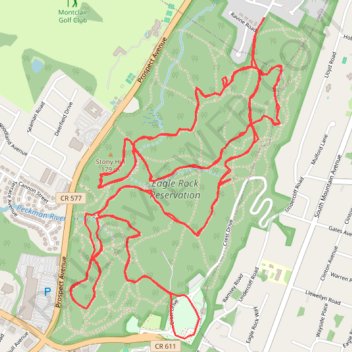
Eagle Rock
- Distance: 10.6 mi
- Elevation gain: 243 m
- Maximum elevation: 198 m
- Elevation loss: 243 m
- Minimum elevation: 159 m
- Moving time: 2 h 14 m
- Moving speed: 4.7 mph
- Maximum speed: 14.6 mph
- Total time: 2 h 49 m
- Global speed: 3.7 mph
Interactive trail map
Trail profile
- Distance: 10.6 mi
- Elevation gain: 243 m
- Maximum elevation: 198 m
- Elevation loss: 243 m
- Minimum elevation: 159 m
- Moving time: 2 h 14 m
- Moving speed: 4.7 mph
- Maximum speed: 14.6 mph
- Total time: 2 h 49 m
- Global speed: 3.7 mph
About this trail
Name: Eagle Rock trail, distance, elevation, map, profile, GPS track
Start: 88, Afterglow Avenue, Verona, Essex County, New Jersey, 07044, United States (40.81833 -74.23378)
End: 88, Afterglow Avenue, Verona, Essex County, New Jersey, 07044, United States (40.81845 -74.23365)
Coordinates: 40.80290 -74.24608 40.81898 -74.23227
Other hiking, mountain biking, running and outdoor activity trails
Click on a trail to view its statistics, map and profile.
Eagle Rock Reservation Loop
United States > New Jersey > Essex County > Verona
Distance: 4.9 mi • Elevation gain: 123 m • Maximum elevation: 198 m
Eagle Rock Reservation Trails
United States > New Jersey > Essex County > West Orange
Distance: 12.4 mi • Elevation gain: 303 m • Maximum elevation: 198 m
Surveying Eagle Rock
United States > New Jersey > Essex County > Verona
Distance: 17.0 mi • Elevation gain: 356 m • Maximum elevation: 200 m
Eagle Rock Reservation
United States > New Jersey > Essex County > West Orange
Distance: 4.5 mi • Elevation gain: 96 m • Maximum elevation: 200 m
Eagle Rock Reservation
United States > New Jersey > Essex County > Verona
Distance: 9.7 mi • Elevation gain: 213 m • Maximum elevation: 198 m
Smoky E-Rock
United States > New Jersey > Essex County > Verona
Distance: 8.9 mi • Elevation gain: 197 m • Maximum elevation: 198 m