Thank you for supporting this site ❤️
Make a donation
Make a donation
Gear up for your next adventure:
As an Amazon Associate, this site earns from qualifying purchases at no extra cost to you.
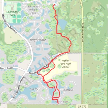
Oakheart Trail
- Distance: 6.4 mi
- Elevation gain: 15 m
- Maximum elevation: 6 m
- Elevation loss: 15 m
- Minimum elevation: 2 m
- Moving time: 54 m 21 s
- Moving speed: 7.1 mph
- Maximum speed: 13.1 mph
- Total time: 1 h 17 m
- Global speed: 5.0 mph
Interactive trail map
Thank you for supporting this site ❤️
Make a donation
Make a donation
Gear up for your next adventure:
As an Amazon Associate, this site earns from qualifying purchases at no extra cost to you.
Trail profile
- Distance: 6.4 mi
- Elevation gain: 15 m
- Maximum elevation: 6 m
- Elevation loss: 15 m
- Minimum elevation: 2 m
- Moving time: 54 m 21 s
- Moving speed: 7.1 mph
- Maximum speed: 13.1 mph
- Total time: 1 h 17 m
- Global speed: 5.0 mph
Thank you for supporting this site ❤️
Make a donation
Make a donation
Gear up for your next adventure:
As an Amazon Associate, this site earns from qualifying purchases at no extra cost to you.
About this trail
Name: Oakheart Trail trail, distance, elevation, map, profile, GPS track
Start: Playmore Road, North Port, Sarasota County, Florida, United States (27.03395 -82.30444)
End: Playmore Road, North Port, Sarasota County, Florida, United States (27.03407 -82.30451)
Coordinates: 27.00530 -82.31013 27.03413 -82.29900
Thank you for supporting this site ❤️
Make a donation
Make a donation
Gear up for your next adventure:
As an Amazon Associate, this site earns from qualifying purchases at no extra cost to you.