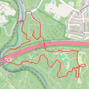
Patapsco Valley State Park - Pickall Area
- Distance: 3.9 mi
- Elevation gain: 140 m
- Maximum elevation: 133 m
- Elevation loss: 140 m
- Minimum elevation: 63 m
- Moving time: 54 m 44 s
- Moving speed: 4.3 mph
- Maximum speed: 9.5 mph
- Total time: 55 m 44 s
- Global speed: 4.2 mph
Interactive trail map
Trail profile
- Distance: 3.9 mi
- Elevation gain: 140 m
- Maximum elevation: 133 m
- Elevation loss: 140 m
- Minimum elevation: 63 m
- Moving time: 54 m 44 s
- Moving speed: 4.3 mph
- Maximum speed: 9.5 mph
- Total time: 55 m 44 s
- Global speed: 4.2 mph
About this trail
Name: Patapsco Valley State Park - Pickall Area trail, distance, elevation, map, profile, GPS track
Coordinates: 39.30228 -76.79614 39.31177 -76.78091
Other hiking, mountain biking, running and outdoor activity trails
Click on a trail to view its statistics, map and profile.
Patapsco Valley State Park - Pickall and Hollofield Areas
United States > Maryland > Howard County > Ellicott City
Distance: 6.4 mi • Elevation gain: 276 m • Maximum elevation: 163 m