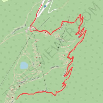
Lee Ski Resort Hiking Trail
- Distance: 4.3 mi
- Elevation gain: 289 m
- Maximum elevation: 2,843 m
- Elevation loss: 290 m
- Minimum elevation: 2,640 m
- Moving time: 2 h 2 m
- Moving speed: 2.1 mph
- Maximum speed: 3.2 mph
- Total time: 2 h 4 m
- Global speed: 2.1 mph
Interactive trail map
Trail profile
- Distance: 4.3 mi
- Elevation gain: 289 m
- Maximum elevation: 2,843 m
- Elevation loss: 290 m
- Minimum elevation: 2,640 m
- Moving time: 2 h 2 m
- Moving speed: 2.1 mph
- Maximum speed: 3.2 mph
- Total time: 2 h 4 m
- Global speed: 2.1 mph
About this trail
Name: Lee Ski Resort Hiking Trail trail, distance, elevation, map, profile, GPS track
Start: Lee Canyon Road, Clark County, Nevada, United States (36.30589 -115.67841)
End: Lee Canyon Road, Clark County, Nevada, United States (36.30596 -115.67833)
Coordinates: 36.29711 -115.68127 36.30596 -115.67326
Other hiking, mountain biking, running and outdoor activity trails
Click on a trail to view its statistics, map and profile.
Spring Mountains - Pioneer Rock and Foxtail Spring
United States > Nevada > Clark County > Lee Canyon
Distance: 4.1 mi • Elevation gain: 412 m • Maximum elevation: 2,944 m